Research completed September 14, 2026 • Sydney’s Burger • Prince George’s County, Maryland
Yes. The county publishes downloadable sewer pipe geometry around the plaza. I successfully queried its public GIS service and extracted 16 intersecting sewer segments, including asset IDs and engineering drawing references. This is enough to build a useful existing-records exhibit today. It does not resolve which private pipe serves Sydney’s, where the contractor’s excavation ends, or the extent of the current replacement.
Open full-size map · Download GIS data
The cyan lines below come directly from the county’s WSSC SEWER LINES layer. Their local records identify WSSC as owner and carry an import date of July 3, 2024. The background is the planning commission’s March 2025 aerial imagery. Neither source documents the 2026 works. Address dots come from the county address layer, which describes approximate building or addressed-portion centers.
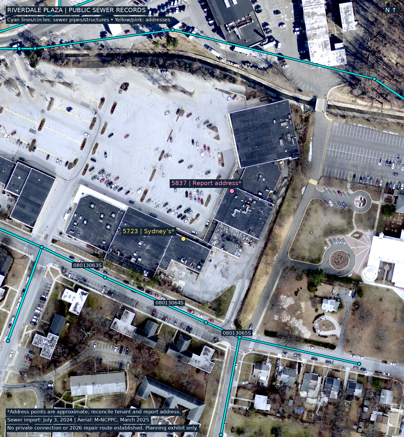
Resolve the address first. Page 2 of Renaud’s published leasing flyer lists Sydney’s Burger at 5723 Riverdale Road and Sitio Restaurant at 5837. The contractor’s August 17 report header uses 5837. This could be a report-header error or a different reference location; it must be reconciled before locating the tenant’s service. The points are context, not surveyed storefront or connection locations.
| Source | Finding | Use and limit |
|---|---|---|
| County Health GIS: WSSC SEWER LINES | Public query succeeded; 16 local features; GeoJSON export works. | Historical main alignment, pipe IDs, engineering drawings, endpoint references. Private service connection unconfirmed. |
| County Sewer/Sewer_Lines | Gravity-pipe query returned the same 16 sewer IDs and import date. | Useful alternate endpoint, not independent field corroboration. Its manhole layer returned 12 sewer structure points through Esri JSON; these were converted to GeoJSON. All carry the same July 2024 import date. |
| PGAtlas imagery | March 2025, nominal 3-inch layer exported successfully. | Buildings, paved areas and streets as visible then; underground routes are the separate vector overlay. |
| PGAtlas WaterSewer | Water/sewer categories, sewer envelope and basin. | Service planning, not physical pipe alignments. A sewer-category map does not answer Henry’s route question. |
| WSSC WERI engineering records | Plans, finals, house connections and 200-foot sheets are available through approved business access. | Best next source for the missing service-connection record. Not an unrestricted public download. |
The adjacent mapped network gives a concrete starting point: 200-foot sheet 207NE05 and drawings 1948-0112 and 1950-0607. Nearby sewer IDs include 08013064S, 08013065S and 08013063S. These are search leads, not a conclusion that any particular segment receives Sydney’s discharge. Include both 5723 and the report’s 5837 reference, the plaza name, and the existing permit number when requesting the applicable house-connection record and finals.
WSSC’s WERI page requires demonstrated business need and an approval process, typically with notification within one business week. Ask whether JCB or its engineer already has authorized access. For guidance, WSSC lists Development Services at 301-206-8650. Do not make tomorrow’s decision depend on a new account being approved overnight.
QGIS is the best primary tool: open the supplied GeoJSON, add the county/PGAtlas services, and place verified contractor work and georeferenced record plans on separate layers. Use an appropriate local projected coordinate system for measurements; the original county pipe service uses Maryland State Plane, EPSG:2248. This report’s aerial overlay uses EPSG:3857 solely for display. See QGIS data-source documentation.
Leaflet is suitable for a shareable browser map with pipe-ID popups and visible uncertainty labels; its GeoJSON tutorial directly matches the supplied data. GDAL can automate conversion and repeatable refreshes; the EsriJSON driver documents service-data support. None of these tools supplies missing underground observations. Open-source software also does not automatically make all source data unrestricted for republication; preserve attribution and check applicable reuse terms before public distribution.
All rows were returned by the same local bounding-box query. Some intersecting features extend beyond the map edge. Construction year is the source attribute, not a verification of remaining original pipe.
| Sewer ID | Drawing | 200-foot sheet | Upstream reference | Downstream reference | Year |
|---|---|---|---|---|---|
| 08013009S | 1941-0447 | 207NE05 | 08013009M | 08013092M | 1942 |
| 08013015S | 1934-0024 | 207NE05 | 08013015U | 08013014U | 1935 |
| 08013062S | 1948-0112 | 207NE05 | 08013062U | 08013061M | 1948 |
| 08013063S | 1948-0112 | 207NE05 | 08013063M | 08013062U | 1948 |
| 08013064S | 1948-0112 | 207NE05 | 08013064M | 08013063M | 1948 |
| 08013065S | 1950-0607 | 207NE05 | 08013065U | 08013064M | 1950 |
| 08013066S | 1950-0607 | 207NE05 | 08013066M | 08013065U | 1950 |
| 08013067S | 2011-5271B | 206NE05 | 08013067N | 08013066M | 2013 |
| 08013068S | 1948-0112 | 207NE05 | 08013068N | 08013062U | 1948 |
| 08013069S | 1950-0607 | 207NE05 | 08013069N | 08013065U | 1950 |
| 08013092S | 1941-0447 | 207NE05 | 08013092M | 08013008J | 1942 |
| 08014002S | 1941-0447 | 207NE05 | 08014002M | 08013009M | 1942 |
| 08014003S | 1941-0447 | 207NE05 | 08014003M | 08014002M | 1942 |
| 08014004S | 1941-0447 | 207NE05 | 08014004U | 08014003M | 1942 |
| 08015002S | 1934-0024 | 207NE05 | 08015002U | 08013015U | 1934 |
| 08015022S | 1934-0024 | 207NE05 | 08015022M | 08013015U | 1934 |
Queries used envelope −76.9195, 38.9561, −76.9157, 38.9593 in EPSG:4326, spatial intersection, all attribute fields, geometry returned in EPSG:4326, and GeoJSON output. The Health sewer response contained 16 features with no transfer-limit flag. The alternate gravity-pipe endpoint returned the same asset IDs. Exact query URLs and original responses are included in the accompanying GIS archive for reproducibility.
The displayed lines are source geometry without a fabricated connection to either address. The aerial is placed using the export response’s exact projected extent. The county address records carry 2013 edit/verification dates; the leasing flyer independently identifies the tenant bay, but current occupancy should be confirmed on site. There is no retrieved private-lateral record, current survey, established vertical datum, or verification of the 2026 repair. Raw diameter, material and invert fields are preserved in the GeoJSON; their codes, units and datum have not been resolved here. Invert values must not be treated as burial depth. The manhole-layer GeoJSON query initially failed; the supported Esri JSON query succeeded and returned 12 point features in EPSG:4326. These were converted without coordinate changes. Points are shown as cyan circles and are historical GIS locations, not field locates.
Management judgment: public records can materially narrow the investigation and improve Henry’s board exhibit. The absence of a route exhibit is a correctable coordination gap. The data found here does not prove the contractor should already have known the exact private connection, nor does it establish that the proposed remaining footage is wrong.